
Finding fish has never been easier thanks to modern technology and specialized mobile apps designed to help anglers locate their next big catch with precision and confidence.


Gone are the days when fishing relied solely on luck, intuition, and word-of-mouth tips from fellow anglers.
Today’s fishing enthusiasts have access to cutting-edge applications that transform smartphones into powerful fish-finding tools, combining GPS technology, sonar data, weather patterns, and community-driven insights to dramatically improve catch rates.
Whether you’re a seasoned professional or a weekend warrior looking to maximize your time on the water, understanding how these fish-finding apps work and which features matter most can make the difference between coming home empty-handed and landing the trophy of a lifetime. 🎣
How Fish-Finding Apps Actually Work
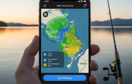
Modern fish-finding applications leverage multiple technologies working in concert to provide anglers with actionable information. At their core, these apps utilize GPS mapping to pinpoint your exact location on any body of water, then overlay this data with bathymetric maps that show underwater topography, depth contours, and structure.
Many advanced applications also integrate with portable sonar devices that attach to your smartphone or tablet. These wireless fish finders cast sonar waves into the water, detecting fish, underwater structures, vegetation, and temperature changes. The data transmits in real-time to your device, creating a visual representation of what’s beneath your boat or kayak.
Beyond hardware integration, these apps tap into massive databases containing historical catch data, seasonal patterns, lunar phases, barometric pressure readings, and water temperature trends. Machine learning algorithms analyze these variables to predict where fish are most likely to be at any given time.
Essential Features to Look for in Fishing Apps
Not all fish-finding applications are created equal. When evaluating which app deserves a spot on your device, consider these critical features that separate exceptional tools from mediocre ones.
Real-Time Sonar Capabilities
The ability to connect with portable sonar hardware transforms your smartphone into a genuine fish finder. Look for apps that support Bluetooth connectivity with popular sonar devices, offering clear graphical displays of underwater environments. The best apps show fish icons, depth readings, water temperature, and bottom composition in an easy-to-read format.
Detailed Mapping and Bathymetry
High-resolution maps with depth contours are non-negotiable. Premium apps provide detailed bathymetric charts that reveal drop-offs, channels, underwater humps, and other structures where fish congregate. Some even allow users to create custom maps of their favorite fishing spots using depth data collected during previous trips.
Weather and Solunar Data Integration
Fish behavior correlates strongly with weather conditions and lunar phases. Top-tier apps incorporate real-time weather forecasts, wind speed and direction, barometric pressure trends, and solunar tables that predict peak feeding times. This information helps you plan trips when conditions are optimal.
Community Features and Catch Logs
Learning from other anglers accelerates your success. Apps with robust community features let users share recent catches, favorite spots (with appropriate discretion), effective techniques, and current conditions. Digital catch logs help you track patterns over time, noting what worked where and when.
Top Fish-Finding Apps Transforming Modern Angling
The marketplace offers dozens of fishing applications, each with unique strengths. Here’s an overview of the most popular and effective options currently available.
Fishbrain: The Social Network for Anglers
With over 13 million users worldwide, Fishbrain combines social networking with powerful fishing tools. The app features detailed maps, weather forecasts, and a feed where anglers share catches and tips. The premium version includes advanced forecasts, unlimited catch logging, and access to exclusive fishing spots reported by the community.
Navionics Boating: Professional-Grade Mapping
Originally designed for boaters, Navionics has become a favorite among serious anglers thanks to its exceptional charts and depth contours. The app covers waters worldwide with remarkable detail, including freshwater lakes and coastal areas. The SonarChart feature uses community-sourced depth data to create ultra-detailed bottom maps.
Deeper Smart Sonar: Hardware-Software Integration
The Deeper app works seamlessly with Deeper’s castable sonar devices, turning your phone into a portable fish finder. Cast the sonar ball into the water, and it transmits real-time data showing fish location, depth, temperature, and bottom structure. Perfect for shore fishing, kayaking, or small boat angling.
FishAngler: Comprehensive Fishing Management
FishAngler combines mapping, weather data, solunar tables, and extensive catch logging in one package. The app’s tournament features make it popular with competitive anglers, while its species identification tools help beginners learn what they’ve caught. The Pro version adds marine forecasts and ad-free experience.

Understanding Sonar Technology in Mobile Fishing
Sonar (Sound Navigation and Ranging) technology forms the backbone of electronic fish finding. When integrated with smartphone apps, it provides unprecedented access to underwater information previously available only through expensive mounted units.
Portable sonar devices work by emitting sound waves that travel through water until hitting an object—whether fish, vegetation, or the bottom. These waves bounce back to the sensor, which calculates distance based on return time. The app then displays this information graphically, showing depth, object location, and size.
Modern castable sonars offer dual-beam or multi-beam technology, scanning wider areas with each cast. Some advanced models include GPS integration, allowing you to map entire lakes or rivers by slowly trolling or casting systematically. The collected data syncs with the app, creating permanent records you can reference on future trips.
Maximizing Battery Life During Long Fishing Sessions
Running GPS, sonar connections, and graphically intensive apps drains smartphone batteries quickly. Experienced tech-savvy anglers employ several strategies to extend device life during all-day fishing trips.
Invest in a waterproof power bank with sufficient capacity to recharge your phone multiple times. Look for rugged models designed for outdoor use with at least 10,000mAh capacity. Some anglers mount solar chargers on their boats for virtually unlimited power on sunny days.
Reduce screen brightness to the minimum readable level, and close unnecessary background apps before heading out. Enable airplane mode when cellular service isn’t needed, but remember that this may affect some app features that require internet connectivity. Download maps and charts for offline use whenever possible.
Consider carrying a waterproof case that allows touchscreen operation while protecting your device from water, drops, and harsh conditions. Some cases include built-in batteries for extended runtime without additional bulk.
Reading Underwater Maps Like a Professional
Understanding how to interpret bathymetric maps and sonar readings separates novices from experienced anglers. These visual representations contain valuable information that directly translates to finding fish.
Depth contour lines work similarly to topographic maps on land. Lines close together indicate steep drop-offs or underwater cliffs—prime ambush spots for predatory fish. Wider spacing suggests gradually sloping bottoms. Look for irregularities in otherwise uniform areas, as these often hold fish.
Points, humps, and saddles create current breaks and food concentration zones. Points extending into deeper water allow fish to access multiple depth zones without traveling far. Underwater humps rising from deep water act as magnets for baitfish and the predators hunting them.
Pay attention to vegetation lines shown on advanced maps. Weed edges create natural boundaries where fish patrol for prey. The transition zone between vegetation and open water often produces consistent action, especially during low-light periods.
Combining App Data with Traditional Fishing Knowledge
While technology provides powerful advantages, the most successful anglers blend digital tools with time-tested fishing wisdom. Apps tell you where fish might be, but understanding why they’re there and what they’ll bite makes all the difference.
Use solunar data as a starting point, not gospel. These predictions indicate optimal times, but local conditions often override theoretical peaks. If the app suggests poor fishing but you notice baitfish activity and favorable weather, trust your observations.
Community catch reports provide valuable intel but remember that fishing pressure increases when spots get publicized. Use shared information to identify productive areas, then explore nearby similar structures that receive less attention.
Temperature data from sonar helps locate thermoclines—layers where water temperature changes rapidly. Many fish species suspend at these levels, which can be anywhere from 10 to 40 feet deep depending on season and location. Finding the thermocline dramatically narrows your search area.
Privacy Considerations When Using Fishing Apps
Social features and location sharing offer benefits but also raise privacy concerns. Before posting that trophy catch with GPS coordinates, consider the implications for your favorite fishing spots and personal security.
Most apps allow you to obscure exact locations when sharing catches, showing general areas without pinpoint accuracy. Use this feature to protect productive spots from overcrowding while still participating in the community. Some anglers wait days or weeks before posting catches from sensitive locations.
Be mindful of what background details appear in photos. Landmarks, boat ramps, or distinctive features can reveal locations you intended to keep private. Review images before posting, cropping or blurring identifying elements when necessary.
Review app permissions carefully. Some request access to contacts, photos, and other data beyond what’s necessary for fishing functionality. Grant only essential permissions, and use privacy settings to control what information the app can collect and share.
Offline Capabilities for Remote Fishing Adventures
Many prime fishing locations lack cellular coverage, making offline functionality essential. Premium versions of fishing apps typically allow downloading maps, charts, and reference materials for use without internet connection.
Before heading to remote areas, download all relevant map sections while connected to WiFi. Include larger areas than you think necessary—exploring new spots often leads outside initially planned boundaries. Some apps limit offline map sizes on free tiers, making premium subscriptions worthwhile for wilderness anglers.
Sonar devices connected via Bluetooth work without cellular service, continuing to show real-time underwater data. However, features like weather updates, community feeds, and some advanced forecasting require connectivity. Plan accordingly, checking forecasts before departure.
GPS functionality operates without cellular service, allowing apps to show your position on downloaded maps. This proves invaluable for navigating unfamiliar waters and marking productive spots for future reference.
Seasonal Patterns and App-Assisted Strategy
Fish behavior changes dramatically with seasons, and smart apps help you adapt strategies throughout the year. Historical data, temperature trends, and community reports reveal patterns that guide seasonal approaches.
Spring brings fish shallow as water temperatures rise. Apps showing temperature gradients help locate warming areas where fish move first. Bays, flats, and shallow coves on northern shores often warm fastest, attracting both baitfish and predators.
Summer heat drives many species deeper, seeking cooler water and higher oxygen levels. Apps with detailed bathymetry help identify deep-water structure, thermoclines, and current zones where fish hold during hot months. Early morning and evening bites become more important, information solunar data emphasizes.
Fall patterns often concentrate fish as they feed aggressively before winter. Community reports reveal migration timing and concentration points. Apps tracking baitfish schools (when integrated with advanced sonar) show exactly where predators will be.
Winter fishing requires pinpoint precision, as cold-blooded fish become lethargic and hold tight to specific structures. Detailed mapping showing the deepest holes, warmest water sources, and minimal-current zones becomes critical for success during challenging cold-water periods.
Integrating Multiple Apps for Complete Coverage
No single app excels in every category, leading many serious anglers to run multiple applications simultaneously. This approach combines each tool’s strengths while minimizing individual weaknesses.
Use one app for superior mapping and bathymetry, another for social features and catch reports, and a dedicated sonar app for real-time underwater viewing. While this increases complexity and battery drain, the comprehensive information often justifies the tradeoffs.
Some anglers maintain separate devices to avoid overtaxing a single phone. An older smartphone dedicated to fishing apps, kept in airplane mode except when needed, provides backup navigation and specialized tools without risking your primary device to water damage.
Cross-reference forecasts from multiple sources to identify consensus predictions. When several apps agree on excellent conditions, confidence increases. Contradictory forecasts suggest unstable or transitional weather, often producing unpredictable fishing.
The Future of Fish-Finding Technology
Emerging technologies promise even more powerful fish-finding capabilities in coming years. Augmented reality features already in development will overlay fish locations, structure highlights, and tactical suggestions directly onto your view through the phone camera. 🚀
Artificial intelligence continues improving, with apps learning individual angler preferences and local water characteristics. Future versions may provide personalized recommendations based on your catch history, preferred techniques, and specific goals.
Drone integration offers exciting possibilities, with aerial mapping revealing surface features, baitfish schools, and even large predators in clear water. Some experimental systems already combine drone footage with underwater sonar for unprecedented three-dimensional mapping.
Expanded sensor networks, including community-deployed permanent sonar buoys and satellite-based water quality monitoring, will feed apps with real-time data across entire regions. The collective knowledge of thousands of anglers and countless sensors will make fishing more predictable than ever imagined.
Making Your Investment Worthwhile
Fish-finding apps range from free basic versions to premium subscriptions costing $100+ annually. Determining which features justify expense depends on your fishing frequency, target species, and preferred waters.
Casual anglers visiting well-known waters a few times yearly likely find free versions sufficient. Basic mapping, weather forecasts, and catch logging provide plenty of value without ongoing costs. Many free apps include advertisements—a small price for useful tools.
Dedicated anglers fishing multiple times weekly, especially those exploring new waters or targeting specific species, benefit significantly from premium features. Detailed bathymetry, offline maps, advanced forecasting, and ad-free experiences quickly pay dividends in improved catch rates and time efficiency.
Consider hardware investments carefully. Castable sonar units range from $100 to $300+ depending on features. Shore anglers and kayakers gain tremendous value from these devices, while boat owners might prefer traditional mounted units with larger screens despite higher costs.
Trial periods offered by many premium apps allow risk-free testing. Use free trials during your most active fishing season to evaluate whether advanced features genuinely improve your success before committing to annual subscriptions.
Building Skills Beyond the Technology
While apps provide incredible advantages, they work best when supporting solid fundamental fishing knowledge. Technology amplifies skills rather than replacing them entirely. Invest time learning fish behavior, seasonal patterns, proper tackle selection, and effective techniques.
Use app data to test hypotheses and build personal experience. When the app suggests a location, think critically about why fish might be there. Understanding the reasoning behind predictions makes you a better angler even when technology fails or isn’t available.
Experiment with turning apps off occasionally, relying on observation, intuition, and traditional methods. This practice sharpens skills that technology can’t teach while deepening your connection to the sport and environment.
Most importantly, remember that fishing’s true value extends beyond catching fish. Time on the water provides relaxation, connection with nature, and memorable experiences with friends and family. Let apps enhance these moments rather than dominating them, keeping technology in proper perspective as a tool rather than the entire experience. 🌊